Every property
has a stori
AI-powered property insights. The fastest way to understand a property's true potential for agents, developers, and homeowners.
Planning Controls
Planning Controls
Understand official planning constraints
Instantly review zoning, overlays, council controls, and planning considerations for any property.
Built from verified government planning data.
Site Analysis
Site Analysis
Discover development pathways with rapid AI site analysis
Instantly assess development options from subdivision to renovation, knock-down rebuild to multi unit – backed by verified government sources, the very latest building codes and standards, and deep industry knowledge.
From initial assessment to feasibility in seconds.

AI Intelligence
AI Intelligence
AI-powered property summaries
Turn complex planning information into clear, structured site intelligence. Choose from professional perspectives — planner, architect, engineer, developer, and more — to tailor insights to your needs.
Designed for fast decision making.
Development Activity
Development Activity
View local development activity
View 1000's of enriched planning permits, research development patterns around a property, or discover whats possible in your local neighborhood based on nearby precedents.
Thousands of enriched planning permits, updated regularly.
Council Planning

Council Planning
Transparent council insights
From median processing time and completion rate to housing growth and development stance — council insights have never been this transparent.
AI-assisted realtime council insights.
Risk Assessment
Risk Assessment
Identify hidden risks early
Surface flood overlays, bushfire controls, easements, slope considerations, and planning complexity before committing.
Reduce costly surprises.
Local Demographics

Local Demographics
Deep dive into local insights
Analyse walkability scores, local population size, projected growth, and socio-economic indicators to understand who lives nearby and how the area is changing.
Powered by ABS census data and Google Maps.
Land Titles (Coming Soon)
Land Titles (Coming Soon)
Purchase official land titles
Buy verified land titles for any Victorian property directly through Stori, in partnership with Service Victoria. Confirm ownership, easements, covenants, and encumbrances — available on every tier.
Coming soon — powered by Service Victoria.
3D Immersive Views
Explore properties in 3D
Explore 3D building envelopes, geographic contours, and site topography in realtime — derived from verified government data.
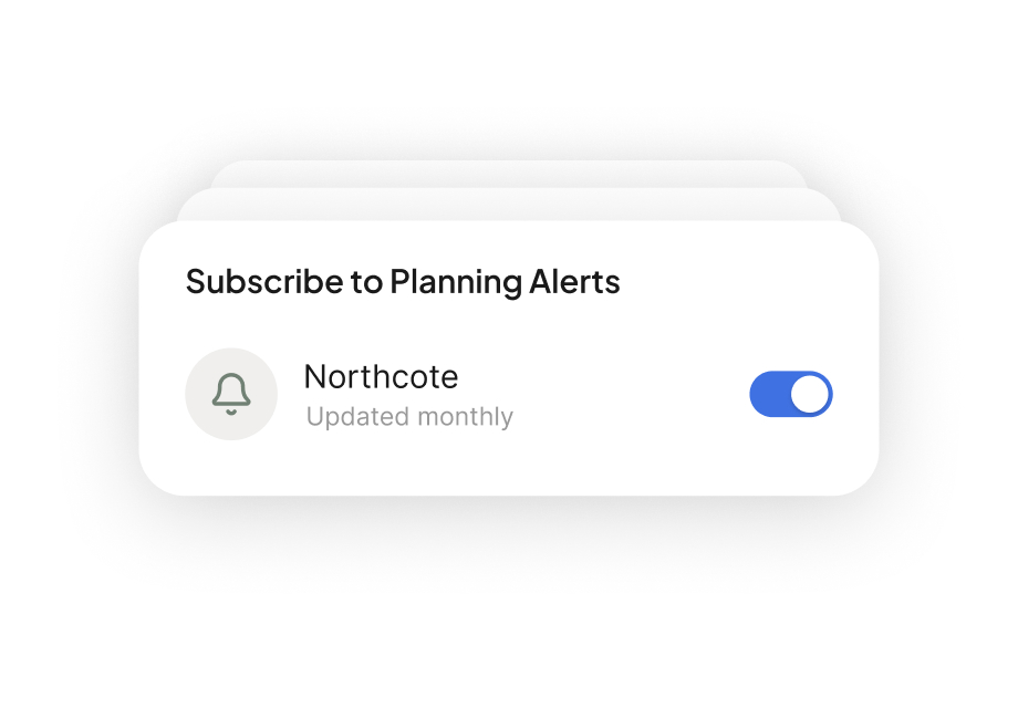
Planning Alerts
Subscribe to planning alerts
Stay ahead of change. Get notified when new planning permits, amendments, or development applications are lodged in your area.
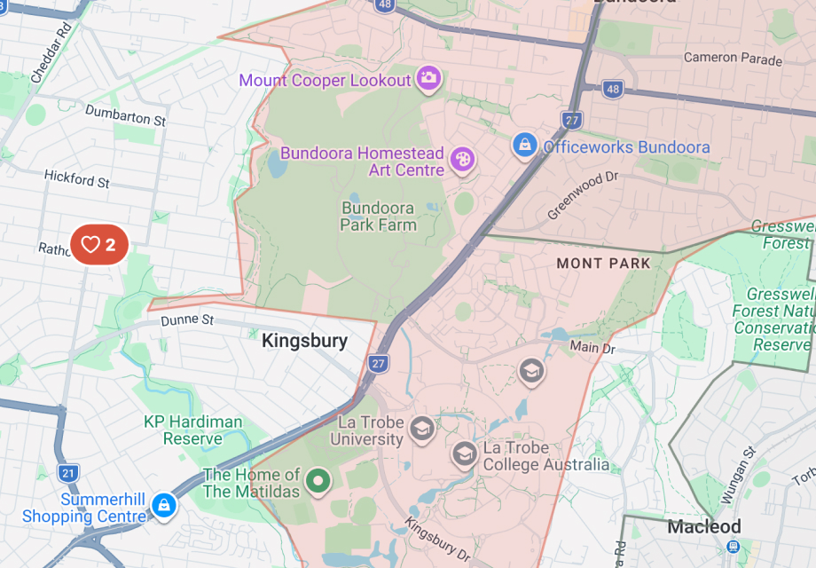
Growth & Overlays
Growth areas and overlays
Identify suburbs earmarked for housing growth, explore overlay boundaries, and understand how strategic planning shapes development potential.
Audience
Who is Stori for?
Property due diligence designed for modern agents, developers, and homeowners.
The best agents don't just sell property, they understand it
Win more listings
Walk into appraisals with site-specific data that shows vendors you know their property better than anyone
Answer any question on the spot
Zoning, overlays, development potential, flood risk. Never say "I'll get back to you" again
Save hours of research
AI-generated property briefs replace the digging you used to do across council sites and planning portals
Uncover hidden value
Surface development potential that vendors and buyers don't know exists, and position yourself as the agent who found it
Build lasting credibility
Verified data builds trust. Clients remember the agent who brought substance, not just salesmanship
In a competitive market, the agents who stand out are the ones with better information at their fingertips. Stori gives you instant access to planning data, development potential, and site intelligence so you can prepare faster, present with confidence, and let the data do the heavy lifting. Less time researching, more time selling.
Make confident decisions about your biggest asset
Know what you can build
Renovation, extension, subdivision. See what your site allows before spending money on architects or planners
Avoid costly surprises
Flood zones, easements, and heritage overlays uncovered upfront, not after you've committed
Discover hidden potential
Development potential you didn't know existed could be worth more than the house itself
Planning in plain language
Complex zoning rules translated so you can make decisions with clarity, not confusion
Understand your neighbourhood
What's being built nearby, who's moving in, and what it means for your property's future
Your home is likely the most valuable thing you own, but most homeowners have no idea what they're actually allowed to do with it. Stori translates complex planning rules into plain language, shows you what you can build, and surfaces risks before they become expensive problems. Whether you're renovating, subdividing, or just curious, you'll finally feel in control.
De-risk projects before you spend a dollar
Site to feasibility in minutes
Subdivision, dual-occ, and multi-unit pathways assessed against current controls. No waiting on consultants
Catch deal-breakers early
Easements, flood, bushfire, slope, and heritage constraints surfaced before you're deep into due diligence
Build your case with precedents
Thousands of enriched planning permits to validate what's actually achievable, not just theoretically possible
Full planning picture
Zoning schedules, overlays, height limits, setbacks, and council-specific rules, all in one place
Gauge council risk
Median processing times, approval rates, and development stance so you know what you're walking into
Every dollar spent on the wrong site is a dollar wasted. Stori gives you instant feasibility insights, from subdivision and dual-occ pathways to overlay constraints and council approval patterns, so you can kill bad deals early and double down on good ones. Replace weeks of consultant back-and-forth with minutes of verified intelligence.
Move faster and smarter than the competition
Screen sites instantly
Assess development feasibility for any property in seconds, before other investors even start their research
De-risk before you invest
Overlays, constraints, and planning history surfaced upfront so you invest with confidence, not hope
Validate with precedents
See exactly what's been approved nearby. Real data to back your assumptions, not gut feel
Find hidden opportunities
Growth corridors, demographic shifts, and undervalued sites identified through data, not word of mouth
Know the council first
Approval rates and processing times tell you whether your timeline is realistic before you start
The best property investments start with better information. Stori lets you screen sites in seconds, validate strategies with real planning precedents, and surface risks before you commit capital. While other investors are still waiting on consultants, you've already moved on to the next opportunity, or away from a bad one.
The best agents don't just sell property, they understand it
In a competitive market, the agents who stand out are the ones with better information at their fingertips. Stori gives you instant access to planning data, development potential, and site intelligence so you can prepare faster, present with confidence, and let the data do the heavy lifting. Less time researching, more time selling.
Win more listings
Walk into appraisals with site-specific data that shows vendors you know their property better than anyone
Answer any question on the spot
Zoning, overlays, development potential, flood risk. Never say "I'll get back to you" again
Save hours of research
AI-generated property briefs replace the digging you used to do across council sites and planning portals
Uncover hidden value
Surface development potential that vendors and buyers don't know exists, and position yourself as the agent who found it
Build lasting credibility
Verified data builds trust. Clients remember the agent who brought substance, not just salesmanship
Make confident decisions about your biggest asset
Your home is likely the most valuable thing you own, but most homeowners have no idea what they're actually allowed to do with it. Stori translates complex planning rules into plain language, shows you what you can build, and surfaces risks before they become expensive problems. Whether you're renovating, subdividing, or just curious, you'll finally feel in control.
Know what you can build
Renovation, extension, subdivision. See what your site allows before spending money on architects or planners
Avoid costly surprises
Flood zones, easements, and heritage overlays uncovered upfront, not after you've committed
Discover hidden potential
Development potential you didn't know existed could be worth more than the house itself
Planning in plain language
Complex zoning rules translated so you can make decisions with clarity, not confusion
Understand your neighbourhood
What's being built nearby, who's moving in, and what it means for your property's future
De-risk projects before you spend a dollar
Every dollar spent on the wrong site is a dollar wasted. Stori gives you instant feasibility insights, from subdivision and dual-occ pathways to overlay constraints and council approval patterns, so you can kill bad deals early and double down on good ones. Replace weeks of consultant back-and-forth with minutes of verified intelligence.
Site to feasibility in minutes
Subdivision, dual-occ, and multi-unit pathways assessed against current controls. No waiting on consultants
Catch deal-breakers early
Easements, flood, bushfire, slope, and heritage constraints surfaced before you're deep into due diligence
Build your case with precedents
Thousands of enriched planning permits to validate what's actually achievable, not just theoretically possible
Full planning picture
Zoning schedules, overlays, height limits, setbacks, and council-specific rules, all in one place
Gauge council risk
Median processing times, approval rates, and development stance so you know what you're walking into
Move faster and smarter than the competition
The best property investments start with better information. Stori lets you screen sites in seconds, validate strategies with real planning precedents, and surface risks before you commit capital. While other investors are still waiting on consultants, you've already moved on to the next opportunity, or away from a bad one.
Screen sites instantly
Assess development feasibility for any property in seconds, before other investors even start their research
De-risk before you invest
Overlays, constraints, and planning history surfaced upfront so you invest with confidence, not hope
Validate with precedents
See exactly what's been approved nearby. Real data to back your assumptions, not gut feel
Find hidden opportunities
Growth corridors, demographic shifts, and undervalued sites identified through data, not word of mouth
Know the council first
Approval rates and processing times tell you whether your timeline is realistic before you start
Pricing
Choose your plan
Search any property for free. Subscribe for deeper analysis.
Starter
Everything you need to research smarter and move faster
A$25/mo
AI Credits
Site Potential
Instantly uncover what you can build. AI analyses zoning, overlays, and site conditions to reveal development pathways you might miss.
Area Analysis
Spot opportunities others miss. See planning permits, housing growth trends, and school catchment zones in your target area
Council Insights
Know how your council actually operates. Housing targets, approval stance, common delays, and strategy that shapes what gets built
Planning Permits & Alerts
Never miss a relevant permit. Search thousands of enriched applications and get notified when new ones appear near you
AI Site Potential
25 credits
Property search (Victoria only)
Property info (address, council, lot size, ID etc)
Zone & planning overlays
Site dimensions & terrain
2D & 3D
Interactive maps
Planning Alerts
3
Council insights
Save & share properties
Up to 15
Access to Land Title purchase
Not included
Cost analysis
PDF Export
Pro
Higher AI volume and pro-level analysis for serious professionals
A$35/mo
AI Credits
Site Potential Pro
Go deeper with multi-persona pathway analysis, local building costs, and nearby approved developments so you can present with authority.
Advanced Area Analysis
Full neighbourhood intelligence. Unlimited alerts, development activity, infrastructure, walkability, demographics, and flight paths
Design Precedents
See what's already been approved nearby. Real precedents that strengthen your case and inform your design
Advanced Council Insights
Understand what gets approved and why. Approval rates, trends, common refusal reasons, and AI-powered council analysis
Planning Permit Alerts
Stay ahead of the market. Unlimited alerts so you're always first to know about new permits in your area
PDF Export
Share professionally. Unlimited PDF reports you can send to clients, stakeholders, or your own records
Cost Calculator
Budget with confidence. Cost per square metre estimates, national averages by building type and finish level, and AI blowout risk analysis to protect your margins
AI Site Potential Pro
50 credits
Property search (Victoria only)
Property info (address, council, lot size, ID etc)
Zone & planning overlays
Site dimensions & terrain
2D & 3D
Interactive maps
Planning Alerts
Unlimited
Council insights
PDF Export
Unlimited
Cost analysis
Save & share properties
Unlimited
Access to Land Title purchase
Teams
Give every team member Pro power at a fraction of the cost
A$25/seat/mo
Pro Power, Starter Price
Every team member gets full Pro access including AI credits, unlimited alerts, PDF exports, and advanced analysis for roughly the cost of a Starter plan per seat
Volume Pricing
The more seats you add, the less you pay per seat — tiered discounts kick in automatically from 5+ members
Centralised Billing
One invoice, one admin. Add or remove seats as your team grows, with no per-user billing headaches
Everything in Pro
Team members
Up to 20
Centralised billing & admin
Tiered volume pricing
AI Credits
Site Potential
Instantly uncover what you can build. AI analyses zoning, overlays, and site conditions to reveal development pathways you might miss.
Area Analysis
Spot opportunities others miss. See planning permits, housing growth trends, and school catchment zones in your target area
Council Insights
Know how your council actually operates. Housing targets, approval stance, common delays, and strategy that shapes what gets built
Planning Permits & Alerts
Never miss a relevant permit. Search thousands of enriched applications and get notified when new ones appear near you
AI Site Potential
25 credits
Property search (Victoria only)
Property info (address, council, lot size, ID etc)
Zone & planning overlays
Site dimensions & terrain
2D & 3D
Interactive maps
Planning Alerts
3
Council insights
Save & share properties
Up to 15
Access to Land Title purchase
Not included
Cost analysis
PDF Export
AI Credits
Site Potential Pro
Go deeper with multi-persona pathway analysis, local building costs, and nearby approved developments so you can present with authority.
Advanced Area Analysis
Full neighbourhood intelligence. Unlimited alerts, development activity, infrastructure, walkability, demographics, and flight paths
Design Precedents
See what's already been approved nearby. Real precedents that strengthen your case and inform your design
Advanced Council Insights
Understand what gets approved and why. Approval rates, trends, common refusal reasons, and AI-powered council analysis
Planning Permit Alerts
Stay ahead of the market. Unlimited alerts so you're always first to know about new permits in your area
PDF Export
Share professionally. Unlimited PDF reports you can send to clients, stakeholders, or your own records
Cost Calculator
Budget with confidence. Cost per square metre estimates, national averages by building type and finish level, and AI blowout risk analysis to protect your margins
AI Site Potential Pro
50 credits
Property search (Victoria only)
Property info (address, council, lot size, ID etc)
Zone & planning overlays
Site dimensions & terrain
2D & 3D
Interactive maps
Planning Alerts
Unlimited
Council insights
PDF Export
Unlimited
Cost analysis
Save & share properties
Unlimited
Access to Land Title purchase
Pro Power, Starter Price
Every team member gets full Pro access including AI credits, unlimited alerts, PDF exports, and advanced analysis for roughly the cost of a Starter plan per seat
Volume Pricing
The more seats you add, the less you pay per seat — tiered discounts kick in automatically from 5+ members
Centralised Billing
One invoice, one admin. Add or remove seats as your team grows, with no per-user billing headaches
Everything in Pro
Team members
Up to 20
Centralised billing & admin
Tiered volume pricing
FAQ
Clear answers for property professionals
A practical overview of what Stori covers, where each feature lives, and how it all connects.
Stori is a property intelligence platform that brings together planning controls, zoning data, overlays, development activity, and AI-powered site analysis into one unified view. It helps agents, developers, and homeowners understand a property's true potential in minutes rather than days.
Stori currently covers all of Victoria, Australia, with planning data sourced from verified government databases. National coverage is on the roadmap and coming soon.
All planning data is sourced directly from official Victorian government databases including VicPlan, council planning schemes, and VicMap. We update regularly to reflect the latest gazetted changes.
The AI analyses all available planning controls, overlays, site dimensions, and development context to generate a structured summary of a property's development potential. It highlights key opportunities, constraints, and considerations relevant to your specific use case.
Stori is built for real estate agents assessing listings, property developers evaluating sites, buyers agents doing due diligence, and homeowners exploring renovation or subdivision potential.
Yes. Stori tracks thousands of enriched planning permits across Victorian councils, letting you review nearby applications, approvals, and development patterns around any property.
Absolutely. Your searches and saved properties are private to your account. We never share individual usage data with third parties.
Starter includes 25 AI credits per month for site potential summaries, area analysis with planning permits and alerts (up to 3), council insights, and a construction cost calculator. Pro upgrades you to 50 AI credits at 30% less per credit, adds unlimited planning alerts, development activity tracking, design precedents, demographics, advanced council and cost analysis, unlimited PDF exports, and unlimited saved properties.